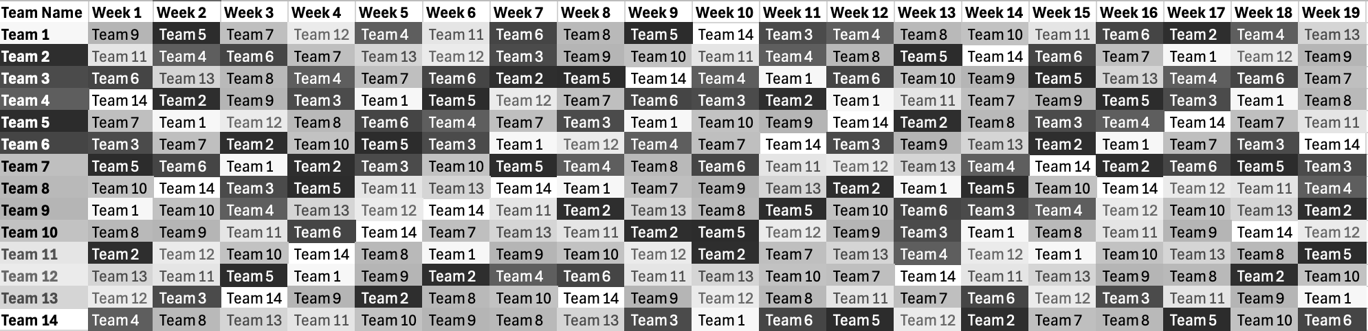
One evening, my partner metioned how he was in charge of creating a fantasy basketball schedule for his two-conference league and he would be doing so manually.
This schedule needed every team to play teams within their conference twice, and all other teams once.
There also would ideally be a 4 game buffer between games having the same two teams.
I thought to myself, I bet I could write a script that could do this for you, and so here it is for you, too.
Tools & Techniques Used: Python, Pandas, iterative design
This project combines spatial analysis and computational design to develop a tool for exploring all of the potential locations for urban agriculture within New York City.
More than 16% of New York City's residents face food insecurity, while there are more than 30,000 acres of land potential suitable for agriculture within the city.
The Little Apple is not a tool to just identify locations, it is a tool to empower community members to choose locations that fit within their cultural fabric.
It is the hope of this project that it is just the beginning of a larger push for resources and action in support of urban agriculture within NYC.
Completed as my capstone project for the MS Computational Design Practices program at Columbia University.
Tools & Techniques Used: Vue, JS, HTML, CSS, QGIS, Mapbox, Rhino, Grasshopper
For this project I wanted to reconsider the visualization of spatial data, specifically to accomodate data that is harmful.
I decided to focus on the dataset of functioning abortion clinics within the United States, whose locations are best kept as unknown as possible in order to protect individuals who use their services.
While abortion is the primary topic of debate at these clinics, they offer many more services that make them integral for healthcare.
But in some parts of the country you will need to travel more than 500 miles to reach a center.
This project seeks to highlight the absense of these critical healthcare locations using sound rather than visible data points.
Completed as part of my work in the MS Computational Design Practices program at Columbia University.
Tools & Techniques Used: D3, Oscillator node, JS, HTML, CSS
This project was an exercise in graphic design.
I was tasked with designing an entire 8.5" x 11" booklet based on the color red.
Ruminating on red, and its relationship to errors, I sought out to create a book of errors and ended up creating a booklet on ghost words: words that made their way into a dictionary even though they didn't exist.
Completed as part of my work in the MS Computational Design Practices program at Columbia University.
Tools & Adobe InDesign
This research project was developed as an extension of my work developing the Little Apple.
It is meant to offer an additional form of analysis through which ideal locations for urban agriculture can be identified within New York City.
Completed as part of my work in the MS Computational Design Practices program at Columbia University.
Tools & Techniques Used: Python, Pandas, K-means Clustering, Hierarchical Clustering, DBSCAN
The goal of this project was to produce a report exploring and potentially answering a spatial research question.
For this, we decided to focus on amenity density within the city, specifically focusing on areas outside walking distance from subway stations.
As a result, we were able to conclude what some of the most over and underserved neighborhoods are, as well as which neighborhood(s) are least supportive to individuals with ambulatory disabilities.
Completed as part of my work in the MS Computational Design Practices program at Columbia University.
Tools & Techniques Used: ArcGIS, QGIS, Network Analysis, Tessellation, Metric Normalization, Rasterization of Vector Maps, Raster Addition
The goal of this model is to utilize computational design to develop ideal bubble diagrams for architecture projects utilizing J files.
The only information needed to complete the model is room name, adjacencies, and floor.
Tools & Techniques Used: Rhino, Grasshopper, Python, JSON
This project draws upon the data William Still collected as he assisted freedom-seekers along the Underground Railroad, which was recently digitized by Nick Sacco.
In visualizing this data, we can not only discover trends and patterns, but we can fully recognize Still's invaluable work.
Completed as part of my work in the MS Computational Design Practices program at Columbia University.
Tools & Techniques Used: HTML, CSS, JS, D3, GeoJson
 Comparison of buffer methods
The goal of this project was to produce one figure suitable for inclusion within an academic paper that describes the analysis and findings when considering street trees surrounding McCarren Park in Brooklyn, NY (including a comparison of the calculations when determined by straight-line distance buffers versus networked distances along the street).
Completed as part of my work in the MS Computational Design Practices program at Columbia University.
Tools & Techniques Used: ArcGIS, QGIS, Network Analysis
Project concept included developing a thematic map that revisiting and re-arguing John Snow’s original claim, intended for online viewing by a general, interested-public, audience.
Completed as part of my work in the MS Computational Design Practices program at Columbia University.
Tools & Techniques Used: ArcGIS, QGIS, Getis Ord Gi* Analysis
Project concept included creating a flow map of the Jordan River Valley using stream network and basins layers developed using ArcGIS Pro geoprocessing tools.
Completed as part of my work in the MS Computational Design Practices program at Columbia University.
Tools & Techniques Used: ArcGIS, QGIS, Fill Sinks, Flow Direction, Flow Accumulation, Stream Threshold, Create Stream Network, Delineate Watersheds
Project concept included developing three map compositions utilizing Landsat imagery and band combinations to create Natural Color Composite, False Color Infrared, and False Color Urban.
It also included composing one map composition showing the wetland change from 1987 to 2017.
Completed as part of my work in the MS Computational Design Practices program at Columbia University.
Tools & Techniques Used: ArcGIS, QGIS, Rendering Composite Images, Creating Training Samples for Automated Image Classification
Project concept was to develop maps utilizing the Mercator, Peters, Robinson, and one additional CRS visualizing the shortest paths between varios cities and how those paths vary based on the projection used.
Completed as part of my work in the MS Computational Design Practices program at Columbia University.
Tools & Techniques Used: QGIS, Reprojection, Adobe Indesign
 Comparing the Population of India's
The goals of this project were to combine raster and vector into a single map, symbolize cities based on their recorded population within the dataset, including labels for the most populated, and focus on a specific region of the world at a scale between 1:15 million and 1:20 million.
Completed as part of my work in the MS Computational Design Practices program at Columbia University.
Tools & Techniques Used: QGIS, Symbology Classification
Project concept envisioning one aspect of the future in 2042 utilizing computational design.
Completed as part of my work in the MS Computational Design Practices program at Columbia University.
Tools & Techniques Used: HTML, CSS, JS, Mapbox, Rhino, Grasshopper, Ladybug, iMovie
This project utilized analysis tools in Grasshopper and Rhino in order to assess which streets would be most optimal for future open streets within New York City.
Conditions measured included area, summer shade, winter sunlight, path disruption, and total population within a two minute walk.
Tools & Techniques Used: Rhino, Grasshopper, DeCodingSpaces
Project concept to create a platform on which community members can recognize and organize around historic and meaningful buildings in their area.
Completed as part of my work in the MS Computational Design Practices program at Columbia University.
Tools & Techniques Used: HTML, CSS, JS, Mapbox
Website redesign as part of my work at the Museum of Food and Drink.
Design was meant to highlight MOFAD's colors and mission while evoking fun and interest in those who visit.
Tools & Techniques Used: Squarespace, CSS
Senior comprehensive project while at Allegheny College drawing upon the work of Dmitri Tymoczko.
I specifically sought out to both further explore what defines "chord space" as well as the potential for topologically composed music.
Through this project, we explore the creation of two new musical pieces through the topological manipulation of two existing pieces in different styles.
Tools & Techniques Used: Topology, LaTeX